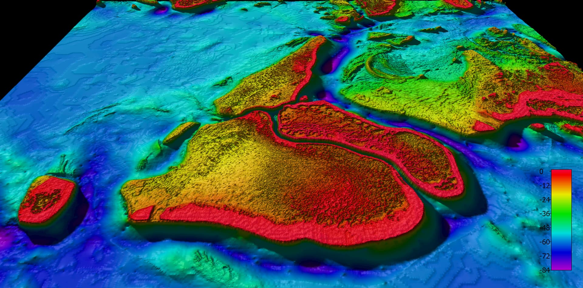
Undersea maps reveal GBR in unprecedented detail
High-resolution seafloor maps released today show 1.5 million square kilometres of Australia’s iconic Great Barrier Reef in unprecedented detail.

The maps are the product of a collaborative project between James Cook University, Geoscience Australia and the Australian Hydrographic Service. This is the first high-resolution mapping of the seafloor of the entire Great Barrier Reef.
JCU’s research leader, Dr Robin Beaman, initiated the project in 2009.
“The Great Barrier Reef data is the first in a series of ‘30-metre’ datasets that will be released as part of this project. This represents the highest resolution depth model of the Great Barrier Reef to date,” he said.
“We’re using cutting-edge scientific techniques to combine historical and newly-acquired bathymetry (undersea mapping or depth) data of the entire northern coastline of Australia,” he said.
“Along with the quality of the new data we’ve acquired, we’ve also been able to access undersea mapping data collected over the past few decades by government and university research programs.”
“Our partners at Geoscience Australia will be releasing open source data of large parts of the coastline as it becomes available. The depth models we’ve built will enhance our understanding of the terrain of the seafloor in shallow waters off the coast of northern Australia.”
Chief of Geoscience Australia's Environmental Geoscience Division, Dr Stuart Minchin, said he was pleased that his team was able to get on board and support this important project with such wide-ranging potential.
“The dataset we’ve released today maps the entire Great Barrier Reef with data that is around eight times higher resolution than what was available previously. This is a vast improvement and it creates huge opportunities for the scientific and policy community, most importantly for the environmental management of the reef,” Dr Minchin said.
“Having greater knowledge of the shape of the reef will be a critical tool for the government agencies responsible for its protection. This gives those organisations a far more detailed view of the reef with which they can identify new reef structures and coral formations.
“Bathymetry data is also an important input for oceanographic modelling which can be used to improve our knowledge of climate change impacts, marine biodiversity and species distribution. It will also support modelling of tides and ocean currents.
“We’ve been able to support the team at JCU, who are specialists in this kind of marine research by contributing our resources and expertise to the project. We’ve also worked with the Australian Hydrographic Service to bring their vast stores of marine mapping data into the project as well.
“Collaborating with these organisations over the past four years has seen us map the entire northern Australian coastline, including the Great Barrier Reef. We saw the value in JCU’s work and the potential of these high-quality datasets to provide greater certainty on Australia’s maritime boundaries for government and other maritime operators.”
Dr Beaman said he was pleased that the Great Barrier Reef depth model was the first dataset to be released, given the reef’s unique marine environment.
“Being based in northern Queensland, JCU prides itself on being at the forefront of scientific research when it comes to the reef; we are committed to providing government and researchers with the spatial information that will ultimately help protect it,” he said.
The series of datasets produced through this project will provide a detailed view of the marine geography of Australia’s northern coastline, providing greater certainty on the location and extent of the country’s maritime boundaries. The datasets will support safety of life at sea, the enforcement of law, and government operations.
Video and 3D images available here
Data available here.
More Information
Media Enquiries:
Geoscience Australia media hotline
P: 1800 882 035
James Cook University Dr Robin Beaman
P: (07) 4232 1693
E: Robin.beaman@jcu.edu.au
Published:
19, January 2018