Why mangroves are important
In Australia, when we think about mangroves, we often think about three things: trees with weird roots, crocs and mozzies. But there is so much more! PhD student Nicolás Younes Cárdenas explains why mangroves are important and why we should keep an eye on them.
Mangroves grow in 124 countries around the world and are very productive ecosystems. Mangroves are trees and bushes that grow only in places where freshwater (rivers) meet saltwater (the sea). If you picture this, there are not many places where rivers meet the sea, and if you can actually visualise these places, they are often surrounded by houses.
This means two things: their distribution is limited and they are losing ground.
Displayed in green in the map below is the mangrove distribution across the world (image modified from Younes Cárdenas et. al. (2017)). If you look closely at Australia, you will find that mangroves grow in the southern regions of Victoria and South Australia. Even more impressive is the fact that there are mangroves in New Zealand, a country that is not normally associated with these tropical forests.
In developing countries, like Ecuador, Madagascar or Bangladesh, people use mangrove forests in many different ways. Some people use their wood for fire, dyes and even medicine. But the main use we give to mangrove forests is for fishing grounds and collecting mussels and those delicious crabs.
In some countries, mangroves are essential to people’s livelihoods and survival. However, in other countries, mangroves are seen as a nuisance and are often converted into prawn ponds for aquaculture or housing developments.
But mangroves do much more than just provide us with food and fuel — they protect us from tsunami waves, storm winds and sea-level rise. They also help to purify water and prevent erosion of beaches. Some people have crunched the math and estimate that one hectare of mangroves provide goods (e.g. food) and services (e.g. wind attenuation) valued at more than USD$294,000 each year.
Think about that for a second. Imagine that you buy your house just behind a mangrove forest and your mate buys an identical house down the road where there are no mangroves. Suddenly, a violent storm forms and brings higher-than-normal winds and waves. While you will be all cosy and dry watching the storm go by, your mate will be trying to keep the water out of their front door and hoping the wind does not tear the roof apart.
Mangrove forests may be the difference between a huge loss and a small loss. In fact, mangroves are so important, people are planting millions of mangrove trees.
Monitoring these ecosystems
Ok, so mangroves are important – now what? Well, now we must ensure that they are healthy, and we do so by conducting regular field surveys.
Field surveys are a good way of getting very detailed information from the mangroves. They allow us to see and measure mangrove growth, identify species, record animal sightings and much more.
However, field surveys can only cover a small portion of the ecosystem. They are time consuming and require a lot of human effort. After all, one has to navigate through the branched roots, the sticky mud and the bugs to get to the study site! Also, researchers and volunteers need to deal with high humidity and temperature, lots of mozzies and crocs. Mozzies can be worse than crocs! We all agree that field surveys are useful but, if we want to monitor larger areas, we have to use other tools. Namely, satellites.
Satellites have been taking pictures of earth’s surface for more than 30 years. Imagine that you kept all your medical records for the last 30 years and one day you decided to see how tall you were each year. With your medical records you can do that, and we can do the same with satellite imagery. But satellite images can tell us much more than this: we can see if mangroves expand or contract, grow or die, if they have been burned or bashed by storms, or if they have been chopped down for housing.
Satellites pass over Australia on a daily, weekly or fortnightly basis. For my research, I will use the images provided by the Landsat satellites because they have images of the mangroves around Cairns and Darwin dating back to 1987.
The good thing about these satellites is that they capture the images in the visible and invisible regions on the electromagnetic spectrum. In short, this means that satellites ‘see’ the mangroves not only as green (the leaves) or brown (trunk), but they can see in the infra-red region as well.
Plants, in general, are better seen in the infra-red light because they reflect so much infra-red light that they seem to ‘glow’. The healthier the vegetation, the more it glows. This is how we can tell if mangroves are healthy or if they are suffering from drought or disease.
In my research, I will use the infra-red light reflected from mangroves on over 900 images from Cairns and Darwin to assess the health of mangrove forests over the past 30 years. Because mangroves are so important to our communities, it is vital that we identify where sick mangroves are and why. By protecting the mangroves, we protect our communities from natural disasters and ensure a better and healthier environment for future generations.
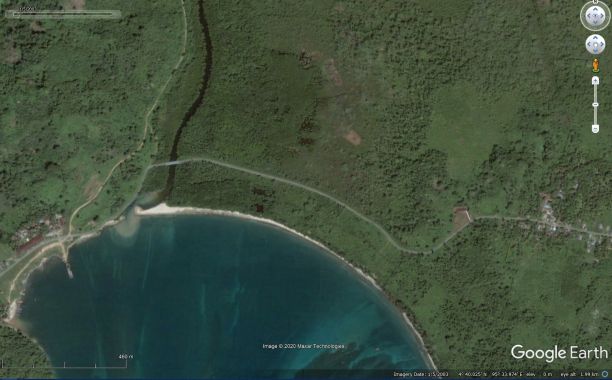
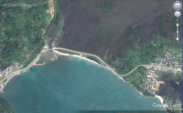
Below are images from the Aceh region in Indonesia (Indonesia (4° 40.061' N; 95° 33.861' E). The left image dates 5 January 2003, about one year before the tragic boxing-day tsunami. The image on the right is from 18 December 2013, almost ten years after the tsunami. Satellite images make it easy to see the extent of the damage and how fast (or, in this case, slow) the recovery of mangrove ecosystems are after a catastrophic event.
“By protecting the mangroves, we protect our communities from natural disasters and ensure a better and healthier environment for future generations.”
Nicolás Younes, JCU PhD Candidate
Working with satellites is like going back in time and measuring the pulse of the ecosystem
To me, knowing how ecosystems naturally change over time is very intriguing and exciting. Not only because I can actually see and measure these changes, but also because I'm required to develop new skills. Without knowing how to program or code, this work would have to be done manually and would require a lot of work.
Aside from learning all about satellites and mangroves, I need to learn how to program and here lies the greatest challenge for me. You can read my work on why we — adults and kids alike — need to learn to code and take full advantage of technology.
(Younes' PhD thesis "Examining spatiotemporal changes in the phenology of Australian mangroves using satellite image" is published on JCU Research Online).