Written By
Mykala Wright
College
College of Science and Engineering
Publish Date
15 February 2022
Related Study Areas
Who run the world?
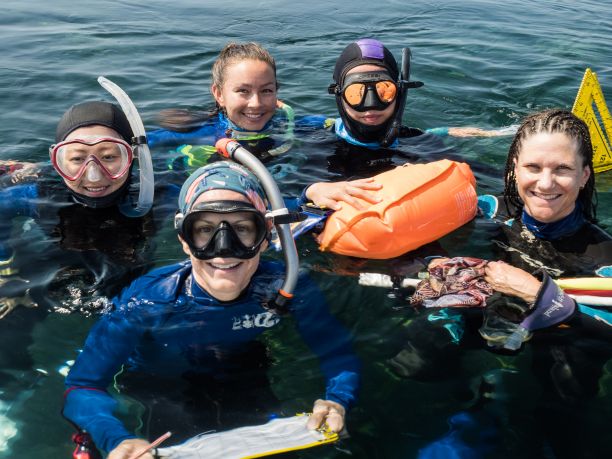
In late 2021, an all-female team of researchers set sail on a six-day expedition to the Great Barrier Reef (GBR) to trial new and innovative methods to monitor its health. On board was JCU Senior Researcher Dr Katie Chartrand.
The Reef Women expedition was part of Great Reef Census, a 12-week citizen science project run by conservation group Citizens of the Great Barrier Reef.
Katie’s role in the expedition was to lead science delivery and integration to achieve scalable science that will support reef management and conservation goals.
“The focus of the trip was to bring together some of the outstanding women researchers, not only in the science community, but also the knowledge and expertise of women that are actively working out on the Reef every day,” Katie says.
The trip included a team of 15 women from JCU, Citizens of the Great Barrier Reef, the local tourism industry, and the Torres Strait community. The expedition was a chance to highlight the significant contribution that female scientists, photographers and conservationists are making to reef research.
“This trip was an opportunity for us to demonstrate that women are some of the leading researchers out here on the water doing the hard work that needs to be done to support our Reef’s future,” Katie says. “I think it’s important for us to come together and to showcase the great work that we’re all doing in this cooperative, collaborative nature.”
Katie says she is grateful to have had some of the Traditional Owners’ unique perspectives and knowledge of the Reef on board during the expedition.
“Having women from the Torres Strait join us on this trip was really meaningful to me. Their expertise is fundamental to the successful management of the GBR and understanding its cultural value,” she says. “It’s very powerful to hear from their experiences and about their life work. I hope that we can continue to work together to drive what they’d like to see in terms of managing their Sea Country with our support more effectively.”


A mission to monitor
During their week on the water, the researchers visited the remote Ribbon Reef section of the GBR, where they surveyed 120 sites across 45 reefs and captured over 11 thousand images.
“We surveyed many areas that aren’t currently being monitored as part of regular programs. Capturing a snapshot of reef conditions with imagery is an approach that hasn’t really been used in this way before. We hope it can provide complementary information to the existing detailed monitoring done at a smaller number of sites,” Katie says.
The team used the trip as an opportunity to trial different methods for mapping sea cucumber populations, which will eventually help establish new monitoring programs.
“There is uncertainty around the status of sea cucumber populations on the GBR, despite the importance of these animals and their role in reef health. We helped collect some early data and trialled new methods to feed into the monitoring design in some shallower reef top areas,” Katie says.
“We invited researchers like Dr Karen Joyce, an expert in remote sensing and aerial drone surveys of reef tops, to join our expedition. We want to team up with other researchers to maximise what we collect while we are out on these trips. The most costly part of research and monitoring the Reef is vessel time, and expeditions like this create an opportunity to share what is often the biggest cost to any research program. ”
On the expedition, the team also mapped seagrass populations. There is more seagrass covering the GBR than there is coral, and seagrass meadows play a vital role in the marine ecosystem. Not only do they provide habitat for numerous organisms, but they also help filter the water of sediments and nutrients from land-based runoff.
Deepwater seagrass meadows within the GBR are notoriously difficult to map, and can extend down to water depths of around 50 metres.
“Seagrasses are incredibly valuable and often overlooked, historically, by the broader community. They’re critical nursery grounds for many fisheries and recently a big focus has been on their ability to capture and store carbon for long periods of time. In fact, research suggests they do it better than their terrestrial counterparts like forests, but much work is still needed to understand how deepwater seagrasses of the GBR contribute to carbon storage,” Katie says.
“Great Reef Census, with its scalability, presents an opportunity to look at these important components of the World Heritage Area and start capturing this more challenging information.”
What is Great Reef Census?
The Reef Women expedition was the first and biggest expedition of Great Reef Census for 2021. Delivered by Citizens of the Great Barrier Reef in partnership with JCU, the Great Barrier Reef Marine Park Authority, the Australian Institute of Marine Science and The University of Queensland, Great Reef Census is a project that harnesses the power of citizen science to help protect the GBR — one photo at a time.
The GBR is the largest coral reef ecosystem on Earth, and given its expansive size, only 5-10 per cent of it is regularly surveyed. In addition, disturbances such as coral bleaching or extreme weather events have inconsistent impacts on its health — some reefs are left degraded while others remain healthy.
“In terms of scale, it’s incredibly difficult with logistics and budgets to have detailed monitoring programs in place that capture the condition of the GBR everywhere,” Katie says.
“Typically, we rely on predictive models based on where we do have that detailed monitoring to forecast what we expect is happening in other parts of the Reef. Great Reef Census is looking to fill in those gaps in our data, whether it is validating the predictions or feeding in additional information about the health of reefs that aren’t usually surveyed.”
The Census project does this by calling on Reef visitors to take georeferenced photos of its condition while out on the water.
“The aim is to bring together this flotilla of research vessels — whether that be tourism and dive boats, tugboats, fishing vessels or super yachts — where we all capture a snapshot in time of the Reef’s condition through reefscape style images,” Katie says.
“The idea is that Great Reef Census can be used to fill in all kinds of important gaps in knowledge at scale, that go beyond what we can possibly achieve through science and our classic research structures alone. It’s really everyone’s reef, and I think we can all contribute to ensuring its condition in the future.”
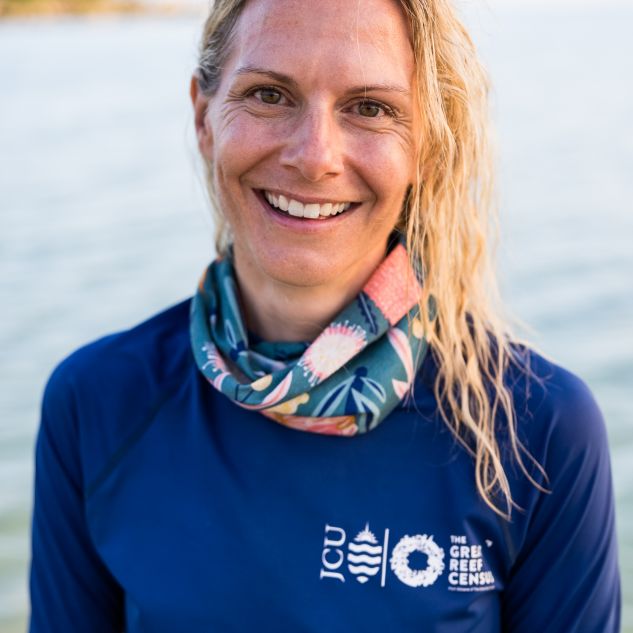
JCU Senior Researcher Dr Katie Chartrand


Conservation through science and education
Last year’s Great Reef Census — the first ever of its kind — played a vital role in broadening our knowledge of important ‘source reefs’, which are healthy reefs that have the capacity to produce large numbers of coral larvae, the first stage of life for the next generation. These help to restore damaged coral populations through the mass spawning and reproductive efforts that occur each year naturally on the GBR.
“Last year a subset of photos were captured and analysed. These photos helped to produce updated maps and models of where we expect to see source reefs, which play a significant role in helping the Reef stay resilient. That dataset has now been directly fed back to managers who are using it to determine where they will be putting their efforts and targeting their resources,” Katie says.
Katie says that while the main goal of the Census project is to collect scientific data to advance management initiatives, she is also excited by the project’s potential to educate the broader public and inspire support for conservation efforts.
“I think this project is a way for us to capture the patchwork nature of the Reef, in terms of some areas looking spectacular while others have had severe disturbance. It’s an opportunity to teach people that a reef system is not necessarily made up solely of live coral. There are areas that naturally consist of sand, rubble and other benthic communities that make up a healthy ecosystem for the reef,” she says.
Katie emphasises the need to broaden the scope of conservation efforts in the face of accelerating threats to the GBR.
“Given the threats from climate change, we need to focus on politicians and getting them to take climate emissions and targets more seriously. The educational aspect of projects like Great Reef Census can inspire meaningful engagement around what’s currently happening on the Reef,” she says.
“I find the Great Reef Census is unique in taking a stride towards closing the loop between inspirational citizen science and impactful reef outcomes. The program strives to not only educate or inspire, but to ensure our collective effort in Census is not in vain. Every photo captured and analysed is part of the power of big data and meaningful science.”
Calling all citizen scientists, near and far
If you want to get involved but don’t have access to the GBR or an underwater camera, phase two of Great Reef Census is for you. While phase one entails being out on the water and capturing images, phase two involves analysing those images. It begins in mid-2022 and anyone can participate, from anywhere in the world.
“This program is not just meant for those that are on the Reef that help us capture the images. It allows you, wherever you may be, to sit at your computer and help,” Katie says.
“The idea is that if you’re in Amsterdam or Seattle or even here in Cairns, during phase two you can get online and analyse the photos as little or as much as you want to do.”
Katie compares the process to Paint By Numbers.
“You go to greatreefcensus.org, where there will be a portal that steps you through how to analyse the photos. Typically, you select a reef image and begin to colour in elements like coral or sand that you see in those images. There are guides and instructions to train you,” she says.
“It’s simple and can be done even if you’ve never been on a reef before. Last year we had primary age kids get involved from Thailand and Finland; it’s about people of all ages contributing what they can. We really want to make it as easy as possible and remove any real boundaries so that anyone can participate.”
Want to help the health of the Great Barrier Reef? Get involved in this year’s Great Reef Census.