Media Releases
Mangroves mega-map: scientists survey FNQ coastline
James Cook University scientists have completed a gargantuan task – filming every metre of shoreline, as well as mangrove forests, between Cairns and the tip of Cape York.
Dr Norman Duke and Jock Mackenzie are from the Mangrove Hub at JCU’s Centre for Tropical Water and Aquatic Ecosystem Research (TropWATER).
The pair covered 1500km of coastline by helicopter, recording the condition of shorelines, mangroves and the health of tidal wetlands in all of the major estuarine systems.
They returned with more than 52,000 geotagged high-resolution images, covering every metre of shoreline and more than 50 estuarine outlets.
“In many ways, this is an absolutely magnificent part of Australia with breath-taking scenic shorelines of remote and secluded embayments and beaches, rocky cliffs, expansive sand dunes, perched lakes and extensive fringing mangrove forests. But, when we systematically looked at a number of notable impacts like eroded mangrove vegetation, and their frequency, we also identified reasons for concern,” said Dr Duke.
“With this survey, we now have a baseline from which we can not only assess current shoreline condition down to the last metre, but we can compare future changes. That hasn’t been done before in such detail”.
The scientists catalogued the condition of all parts of the shoreline, identifying and quantifying specific risks in many places and recommending solutions for improving coastal water quality.
These efforts come as part of recent initiatives by federal and state governments to minimise threats to the Great Barrier Reef and other habitats already struggling with increasing temperatures.
“The biggest ongoing and emerging issues on north-eastern Cape York Peninsula shorelines are impacts by feral pigs, shoreline erosion and deterioration, and marginal lands becoming salinated by rising sea levels,” said Dr Duke.
Along with these factors adding to declines in coastal water quality, the scientists also discovered previously undocumented notable damage in specific shoreline locations.
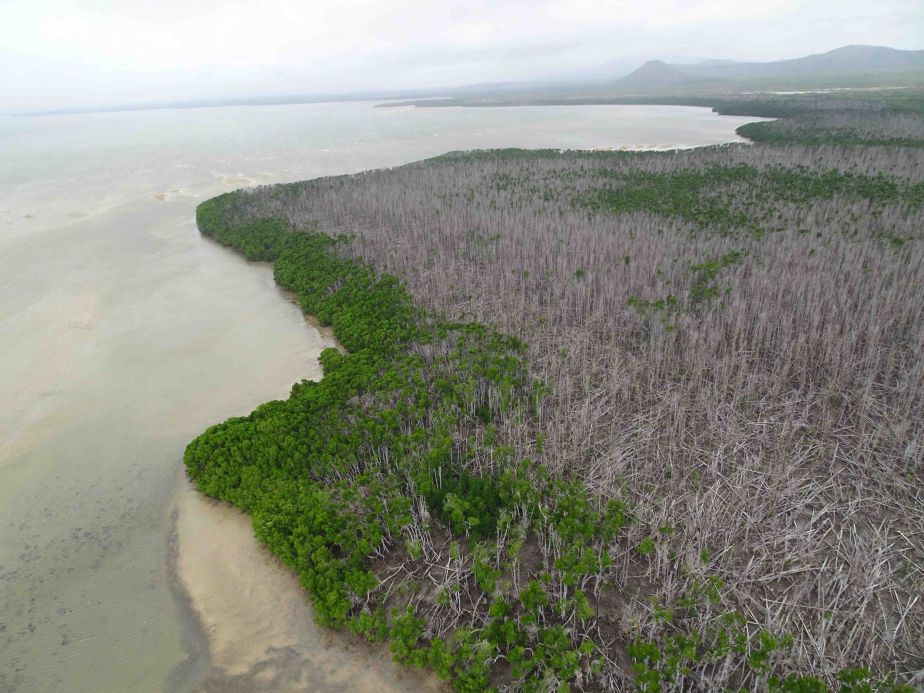
“We found at least two major locations of severe damage to mangrove shorelines. One, near the Starcke River, affected around 600 hectares of mangrove forests. This was most likely caused by two severe Tropical Cyclones in 2014 and 2015 striking the same vicinity. Another damaged area of around 100 hectares of mangroves was observed near the Nesbit River, with this one possibly linked to earlier cyclones in 2005 or 2006.”
Dr Duke said they will make the complete set of images available to interested specialists for analysis, and for public interest.
“It is critical that we know how and where our shorelines are changing. This information will be used to guide and direct local and national management priorities by targeting specific and identifiable issues.
“We think this new photographic and observational database will prove to be an invaluable resource for longer term reference, as well as providing a platform for adding further observations in the future.”
The study was commissioned by the Commonwealth of Australia, Department of the Environment and Energy, Reef Branch and will assist in prioritising future investments in coastal habitats.