Written By
Tianna Killoran
College
College of Science and Engineering
Publish Date
21 April 2022
Related Study Areas
More than just a pretty picture
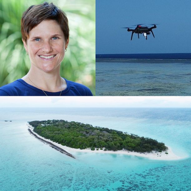
With millions of drone users across the globe, JCU's Associate Professor Karen Joyce realised that every drone flight contained a treasure trove of data about our most valuable ecosystems. If we could unlock this information, what stories could it tell us about our planet? That’s exactly what Karen set out to discover by co-founding GeoNadir, an online drone data sharing platform.
Researchers and innovators like Associate Professor Karen Joyce say that technological innovations with drones and satellites, such as GeoNadir, can help us to write and illustrate new chapters in the story of the earth.
From surveying the Great Barrier Reef using satellite imagery to working with the military in mapping, Karen says she has seen the evolution of drone and satellite technologies since the 1990s.
“As a student, I was always wanting to access more data for my research, but that cost a lot of money. Back in the late 1990s when I first started using satellite data, it cost thousands of dollars to access even a very small data set,” Karen says.
In 2008, the US government started implementing open data policies and began making their satellite data globally available, which Karen says completely shifted the landscape of drones and data research around the world.
“The difference that made to our industry, to our life as researchers and students, was just phenomenal,” she says. “I think many people today expect that you can access free data; you can simply go to a website, download it and use it in any way and innovate with it.”


When the sky isn’t the limit
As Karen began to capture her own images with drones, she realised that she was creating her own personal stockpile of drone data.
“When I started to capture my own drone data for the work I was doing on the reef, I realised that I was becoming part of the problem,” she says. “I was creating my own silo of data, as were all of my colleagues.”
Karen wondered if there was a way she could unlock this data and share it with others, creating stories about our most valuable ecosystems in the process. “There were these people all over the world who had their own little pots of data,” she says.
“People always asked me if they could use my data. I wanted to make it available for others, but it was too hard,” she says. ‘Big data’ like the drones captured, for example, was a complex data set that presented challenges in terms of storage, analysis, visualisation and sharing.
“That’s when we really started building out the idea for GeoNadir. We started to think about what sharing this data might look like, what the experience would involve, and the ways people might be able to contribute to and use this data,” she says. “It has continued to snowball from there.”
The product of Karen and her co-founder Paul Mead’s efforts was GeoNadir, with the name literally describing looking at the earth from above.
“At GeoNadir, we provide a safe storage house for everyone’s drone mapping data, but we don’t keep it under lock and key. We work to be fair, findable, accessible, interoperable and reusable.”
JCU Senior Lecturer and GeoNadir co-founder, Dr Karen Joyce
Incubating innovation
Partnered with the JCU Ideas Lab and supported by the Sandpit to Seed (S2S) fund, GeoNadir became an online open platform for drone operators and the public.
Karen says the platform provides both raw drone images and services in creating orthomosaics, which is where drone images are ‘stitched together’ into a cohesive image of the landscape or waterscape. Researchers can access valuable data about places as far and wide as Green Island near Cairns and Dudelange in Luxembourg.
Collaborating with others has been a key part of the process. “The Ideas Lab staff are great at building the community and bringing together like-minded people with a really great, positive vibe,” she says.
Karen says the Ideas Lab has enabled GeoNadir to provide opportunities for students and connect with others. “It has been a great space for hosting interns and work experience students. Last year we hosted interns from other universities, and this year we’ve had one Work Integrated Learning student from JCU.
“I really enjoy the physical space of the Ideas Lab building. There’s lots of natural light and a variety of different types of spaces suitable for running workshops and collaborating with others,” Karen says.
From data soup to treasure trove
Karen says that, put together, all of this drone data can be used to answer questions about the world around us. But she says the trick is knowing what questions to ask.
“It’s not necessarily about the data, but it’s about the insights you can gain from it,” Karen says. “It’s no good having a tonne of data if you don’t have questions that you want answered.
“You want to use those data points to help you form some sort of insight or information, because that’s where the real value is. Unless you actually have the questions that the data can help you solve or give you insights, then it’s just a soup of numbers. You need to have the questions from the start.”
While Karen says she will continue to use drones to support reef research at JCU and other scientific endeavours, she’s keen to see the future of drones and the ways that GeoNadir can support that.
“We already have drone deliveries occurring here in Australia. There are a couple of places in QLD and the ACT where they deliver burritos or coffee, things like that,” she says.
But Karen says even these developments are about more than convenient delivery of your daily caffeine fix. “It’s not just the drone delivery that is important; they’re also developing the systems and the processes to figure out what it’s going to be like to be able to scale the capabilities of drones and deliver all sorts of things across populated places in the future,” she says.
Drones, and even their automation, are part of our future. “These developments are also something that’s happening in the medical sphere, such as delivering vaccines, taking samples from people who are unwell, and there’s even a defibrillator drone. There are all sorts of ideas and innovations that are being tested along the way.
“As people become more comfortable with drones and discussing their automation, we’re going to see faster adoption of the technology. With that, more regular drone use will see even more data that can support scientific research in the future.”
Want to learn more about drones and geospatial technology? Follow along with some of Karen’s work on her Youtube channel or GeoNadir’s Twitter/X and Instagram accounts. Learn more about how you can create, connect and collaborate with JCU Ideas Lab.
Featured researcher
Karen Joyce
Associate Professor
Associate Professor Karen Joyce graduated from the University of Queensland in 2005 with a PhD in Geographical Sciences. Her focus was on mapping live coral cover using remote sensing. Using her remote sensing expertise for a variety of applications, she has since worked as a Geomatic Engineering Officer in the Australian Army, developed models for spatially explicit mapping across New Zealand’s conservation estate, and developed techniques for integrating remote sensing into all phases of the disaster management cycle.
Karen’s primary area of interest is in creating, applying, and automating remote sensing tools for environmental monitoring and management problems, especially on the Great Barrier Reef. She loves helping people incorporate drones and satellite imaging into their workflows, and is particularly active in encouraging women and young people to consider careers in STEM using drone and geospatial technology.