AI and Computer Vision: Transforming Environmental Monitoring in Northern Australia
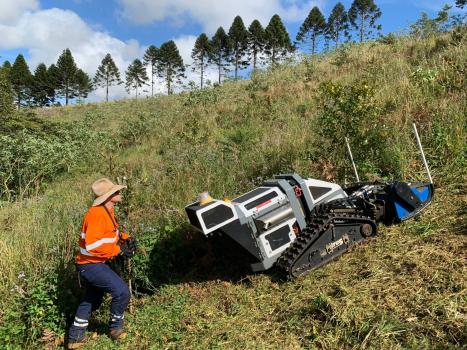
Image: Kevin Huang at computer
As environmental challenges intensify in tropical and coastal regions, the demand for scalable, real-time monitoring solutions has never been greater. From managing water discharge during heavy rainfall to detecting invasive weeds and mapping fire-prone vegetation, the complexity and urgency of environmental monitoring are increasing. Traditional methods, often manual, labour-intensive, and limited in coverage, are no longer sufficient. That’s where artificial intelligence (AI) and computer vision are stepping in to make a real impact.
At James Cook University, Dr. Tao (Kevin) Huang is leading a series of cutting-edge projects that harness AI and computer vision to deliver smart, field-ready monitoring systems designed for the unique conditions of Northern Australia. These projects are showing how intelligent sensing can unlock new capabilities across environmental sectors.
“AI and computer vision are unlocking a new era of environmental intelligence. We’re no longer limited by manual methods or delayed data collection. These technologies allow us to understand and respond to dynamic environmental changes in real time, which is critical for sustainable land and water management. Our goal is to build smart systems that are not only accurate but also accessible and deployable in the field.”
Dr Kevin Huang
Computer Vision-Based IoT Solution for Real-Time Water Discharge Monitoring
In partnership with Cairns Regional Council, Dr. Huang led the development of a computer vision-based IoT system as part of the Smart Catchment Project. The system estimates surface runoff in near real time, replacing traditional flow sensors with scalable, camera-based technology. This edge-deployed solution delivers actionable data quickly and cost-effectively, helping local authorities respond faster to flooding and water quality concerns.
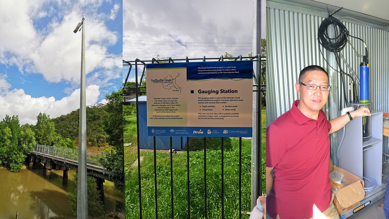
“This project demonstrated that real-time hydrological monitoring can be both scalable and affordable,” explains Dr. Huang. “By combining edge computing with computer vision, we’ve created a system that eliminates the need for traditional, sensor-heavy data collection process. It’s a practical and low-maintenance solution that can be deployed quickly, providing councils with timely data to support informed management.”
AI for Coastal Oil Spill Detection
Building on the Smart Catchment success, Dr. Huang was invited to co-lead an ARC Discovery Project focused on low-cost, AI-enabled IoT systems for environmental monitoring. As part of this project, his work investigates the use of hyperspectral (HSI) and Synthetic Aperture Radar (SAR) remote sensing data, in combination with deep learning models, to detect marine oil spills.
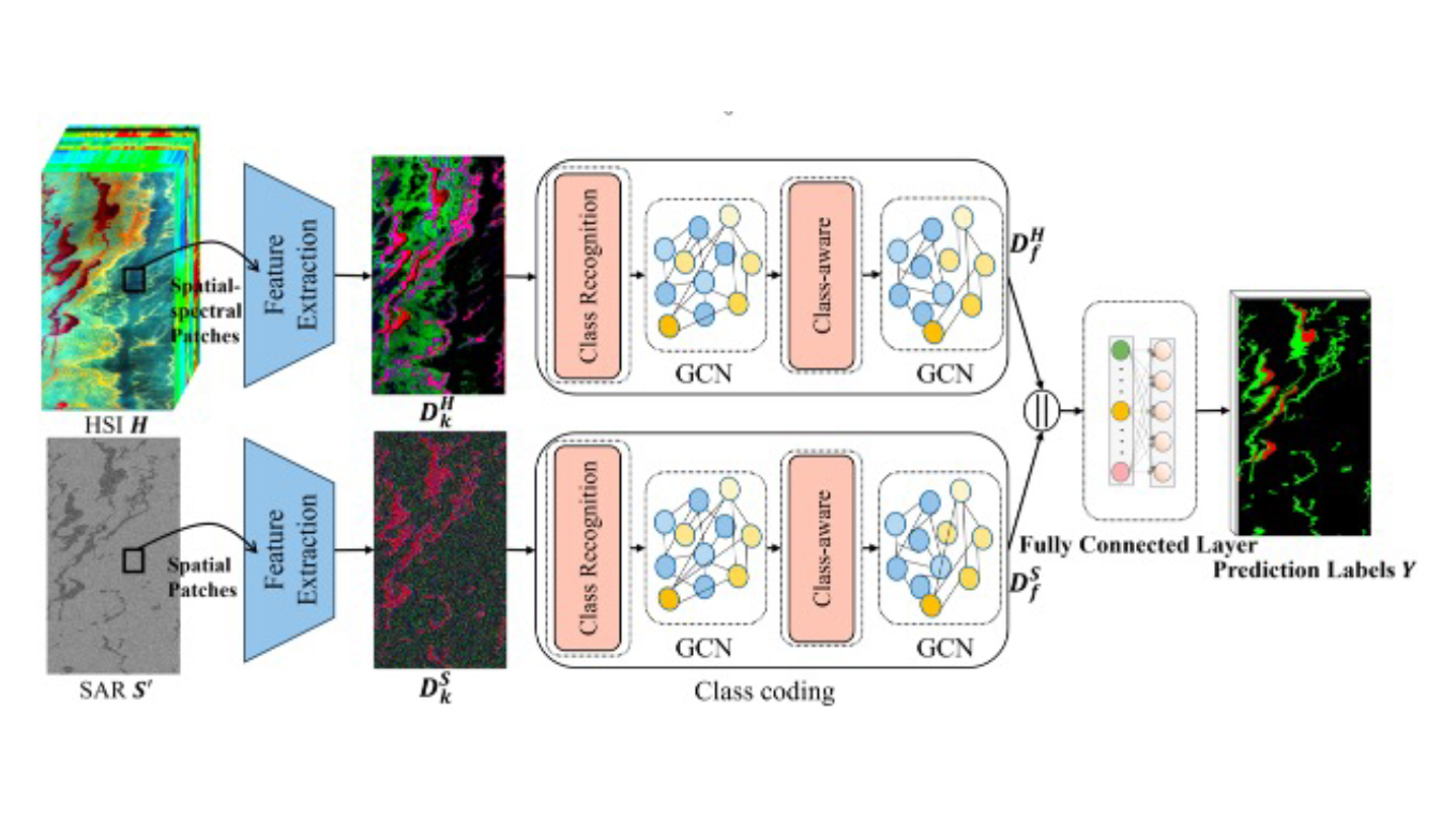
Recent results have been presented at the 2025 IEEE International Geoscience and Remote Sensing Symposium (IGARSS) and published in Remote Sensing Applications: Society and Environment, demonstrating the potential of AI-powered remote sensing for marine hazard detection.
“Detecting oil spills early is critical for protecting marine ecosystems, but traditional methods are often slow or resource-intensive,” says Dr. Huang. “Our work explores how deep learning can interpret fused hyperspectral and SAR remote sensing data to detect spills efficiently over large areas. This approach opens up scalable, near-real-time detection possibilities that could significantly enhance our capacity to respond to environmental emergencies in coastal and offshore settings.”
AI for Forestry Weed Detection
Set to commence soon with the support of the local forestry industry, this project will develop a ground-based AI vision system to detect and map invasive weed species in plantation environments. Using high-resolution RGB imagery, deep learning models will be trained to distinguish between grasses, broadleaf weeds, and young seedlings under varying field conditions.
By enabling precision weed monitoring, the system is expected to reduce the need for manual intervention, improve early-stage seedling survival, and support more sustainable and cost-effective forestry operations.
“Manual weed control is expensive and inefficient at scale,” says Dr. Huang. “By training AI models on real plantation imagery, we’re creating tools that can adapt to real-world conditions and provide forestry managers with critical information early. These tools and technologies can eventually be integrated into a fully autonomous ground-based weed removal system, reducing labour intensity and significantly lowering health and safety risks for workers in rugged or remote environments.”
AI for Fire-Risk Vegetation Mapping
Also beginning shortly, this industry-supported project will focus on identifying and mapping fire-prone vegetation, such as gamba grass and mission grass, using aerial imagery and AI-powered classification models. Drones equipped with RGB sensors will be deployed across representative forest sites to capture vegetation profiles.
The system will generate spatially accurate fire-risk maps, giving land managers the tools to prioritise weed control, enhance fire preparedness, and reduce the ecological impact of wildfires.
“Grasses like gamba and mission grass dramatically increase the fuel load in our forests, turning manageable fires into ecological disasters,” Dr. Huang notes. “Through drone-based imaging and AI-powered analysis, we aim to detect high-risk vegetation before it becomes a threat. The system will support land managers with detailed, spatially accurate risk maps to prioritise weed control and guide fire mitigation strategies. Ultimately, this technology enables proactive intervention, protecting ecosystems and communities from the growing risk of severe wildfires.”
A Future-Focused Approach
Together, these projects illustrate the growing power of AI and computer vision to deliver accurate, low-cost, and real-time monitoring tools for diverse environments. By blending advanced algorithms with practical field deployment, Dr. Huang’s work is helping land managers, local councils, and environmental agencies make smarter, faster decisions.
“The future of environmental monitoring is intelligent, automated, and responsive,” says Dr. Huang. “We’re building that future, one project at a time. With a strong research background in computer vision and deep learning, my work focuses on transforming scientific advances into practical, scalable technologies that serve real-world environmental needs. These projects are just the beginning. We’re creating systems that will empower local communities, governments, and industries to respond faster, manage smarter, and protect ecosystems more effectively. As the environmental challenges grow, so must our tools, and AI is at the heart of that transformation.”
In addition to these initiatives, Dr. Huang is currently collaborating with the Queensland Government on new AI and computer vision–based environmental monitoring projects. These efforts aim to extend the impact of intelligent sensing technologies across broader ecological and regulatory contexts, with further details to be released soon.
Grant Acknowledgment: Australian Government’s Smart Cities and Suburbs Program, Australian Research Council Discovery Project
Contact details