UAV
Remote sensing with UAVs
- Aboriginal and Torres Strait Islander in Marine Science
- Courses
- Future Students
- Current Students
- Research and Teaching
- Partners and Community
- About JCU
- Reputation and Experience
- Celebrating 50 Years
- Academy
- Anthropological Laboratory for Tropical Audiovisual Research (ALTAR)
- Anton Breinl Research Centre
- Agriculture Technology and Adoption Centre (AgTAC)
- Living on Campus
- How to apply
- Advanced Analytical Centre
- Alumni
- AMHHEC
- Aquaculture Solutions
- AusAsian Mental Health Research Group
- ARCSTA
- Area 61
- Association of Australian University Secretaries
- Australian Lions Stinger Research
- Australian Tropical Herbarium
- Australian Quantum & Classical Transport Physics Group
- Boating and Diving
- JCU-CSIRO Partnership
- Employability Edge
- Clinical Psychedelic Research Lab
- Centre for Tropical Biosecurity
- Career Ready Plan
- Careers at JCU
- Careers and Employability
- Chancellery
- Centre for Tropical Bioinformatics and Molecular Biology
- CITBA
- CMT
- CASE
- College of Business, Law and Governance
- College of Healthcare Sciences
- College of Medicine and Dentistry
- College of Science and Engineering
- CPHMVS
- Centre for Disaster Solutions
- CSTFA
- Cyber Security Hub
- Cyclone Testing Station
- The Centre for Disaster Studies
- Daintree Rainforest Observatory
- Defence
- Discover Nature at JCU
- Research Division
- Services and Resources Division
- Education Division
- Elite Athletes
- eResearch
- Environmental Research Complex [ERC]
- Estate
- Fletcherview
- Foundation for Australian Literary Studies
- Gender Equity Action and Research
- General Practice and Rural Medicine
- JCU Orientation
- Give to JCU
- Governance
- Art of Academic Writing
- Art of Academic Editing
- Graduate Research School
- Graduation
- Indigenous Education and Research Centre
- Indigenous Engagement
- Indigenous Legal Needs Project
- Inherent Requirements
- IsoTropics Geochemistry Lab
- IT Services
- International Students
- Research and Innovation Services
- JCU Eduquarium
- JCU Heroes Programs
- JCU Webinars
- JCU Events
- JCU Global Experience
- JCU Ideas Lab
- JCU Job Ready
- JCU Motorsports
- JCU Prizes
- JCU Sport
- JCU Turtle Health Research
- Language and Culture Research Centre
- CEE
- LearnJCU
- Library
- Mabo Decision: 30 years on
- MARF
- Marine Geophysics Laboratory
- New students
- Off-Campus Students
- Office of the Vice Chancellor and President
- Virtual Open Day
- Orpheus
- Open Day
- Outstanding Alumni
- Parents and Partners
- Pathways to university
- Pharmacy Full Scope
- Planning for your future
- Placements
- Policy
- PAHL
- Publications
- Professional Experience Placement
- Queensland Research Centre for Peripheral Vascular Disease
- Rapid Assessment Unit
- RDIM
- Researcher Development Portal
- Roderick Centre for Australian Literature and Creative Writing
- Safety and Wellbeing
- Scholarships
- Contextual Science for Tropical Coastal Ecosystems
- Staff
- State of the Tropics
- Strategic Procurement
- Student Equity and Wellbeing
- Student profiles
- SWIRLnet
- TARL
- TESS
- TREAD
- TropEco for Staff and Students
- TQ Maths Hub
- TUDLab
- Unicare Centre and Unicampus Kids
- UAV
- VAVS Home
- Work Health and Safety
- WHOCC for Vector-borne & NTDs
- Media
- Copyright and Terms of Use
- Australian Institute of Tropical Health & Medicine
- Pay review
Remotely Piloted Aircraft Systems are enhancing tropical research and environmental management at James Cook University
![]()
Also know as:
- RPAS - Remotely Piloted Aircraft Systems
- UAS - Unmanned Aerial Systems
- UAV - Unmanned Aerial Vehicles
- Drones
These systems provide low-cost, high resolution data for environmental mapping, monitoring and management. JCU researchers, working closely with industry partners, use these systems to improve our understanding of marine and terrestrial environments by complimenting traditional fieldwork and satellite data with information collected using drones.
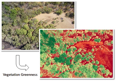
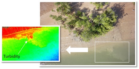
Using a range of sensors including hyperspectral, thermal and photogrammetric cameras with lidar and sonar, JCU researchers are mapping and monitoring:
- terrestrial and marine habitats and biodiversity;
- invasive species such as weeds, ferals and other agricultural pests;
- vegetation health and biomass;
- crop yields and growth; and
- post disaster impacts and recovery (e.g., cyclone or flood).
JCU has:
- 10+ trained pilots engaging in research
- CASA approval for flights
- wide range of research programs
- various CASA registered aircraft
- clubs competing in UAV competitions
Meet some of our aircrafts...
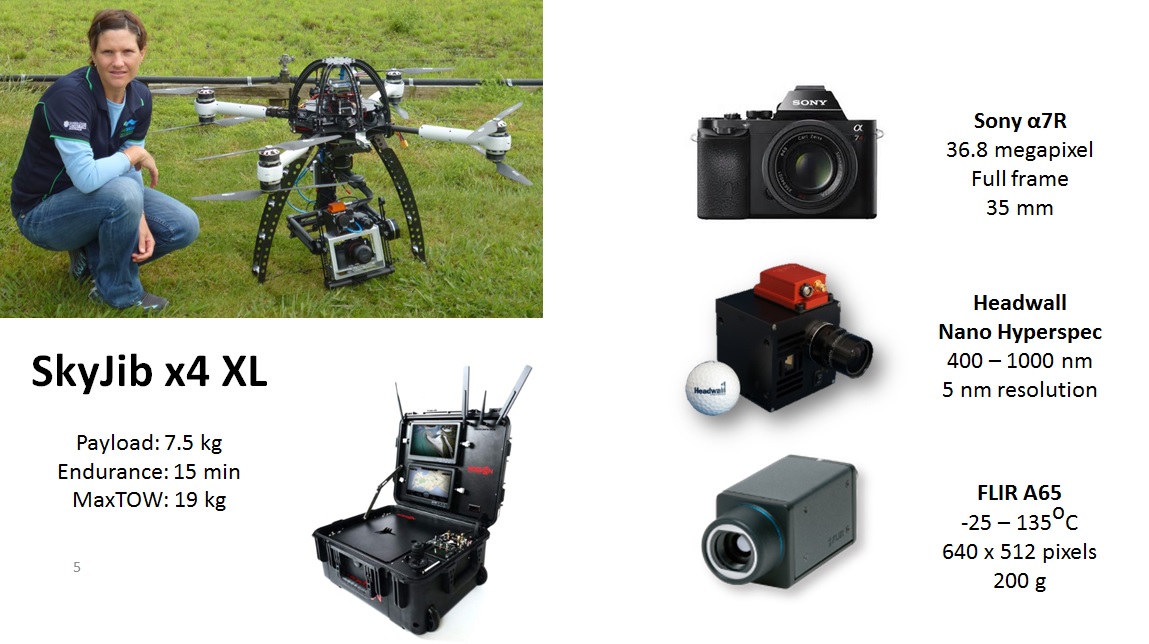
SkyJib x4 name 'Dino'
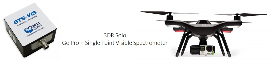
2x 3DR Solo + accessories -- named 'Rainbow Night' & 'Betty'