CADSI Our impact areas Economies Remote Sensing and Hydrodynamic Modelling for Flood-Driven Soil Erosion in Northern Queensland
Remote Sensing and Hydrodynamic Modelling for Flood-Driven Soil Erosion in Northern Queensland
- MRCMHR
- Future Students
- JCU Global Experience
- International Students
- Student experience
- Open Day
- How to apply
- Pathways to university
- Living on Campus
- Courses
- Publications
- Mature students
- Scholarships
- Entry options
- JCU Families
- JCU Heroes Programs
- Aboriginal and Torres Strait Islander in Marine Science
- Elite Athletes
- Defence
- Capability.Co
- AI@JCU
- AALL
- Current Students
- Student Ambassador Program
- New students
- JCU Orientation
- LearnJCU
- Placements
- EDQS
- Unicare Centre and Unicampus Kids
- Graduation
- Off-Campus Students
- JCU Job Ready
- Safety and Wellbeing
- JCU Prizes
- Professional Experience Placement
- Employability Edge
- Art of Academic Writing
- Art of Academic Editing
- Careers and Employability
- Health, Wellbeing and Belonging
- Career Ready Plan
- Careers at JCU
- Partners and Community
- School Outreach and Widening Participation
- Alumni
- International partnerships
- About JCU
- Reputation and Experience
- Chancellery
- Governance
- Celebrating 50 Years
- Academy
- Indigenous Engagement
- Education Division
- Research Festival
- Graduate Research School
- Research Division
- Research and Innovation Services
- CASE
- College of Business, Law and Governance
- College of Healthcare Sciences
- College of Medicine and Dentistry
- College of Science and Engineering
- MPE
- Anthropological Laboratory for Tropical Audiovisual Research (ALTAR)
- Rural Remote and Tropical Health Systems
- Agriculture Technology and Adoption Centre (AgTAC)
- Advanced Analytical Centre
- AMHHEC
- Aquaculture Solutions
- AMHRA
- JCU Digital Wellbeing Group
- ARCSTA
- Lions Marine Research Trust
- Australian Tropical Herbarium
- Australian Quantum & Classical Transport Physics Group
- Boating and Diving
- Clinical Psychedelic Research Lab
- Centre for Tropical Biosecurity
- Centre for Tropical Bioinformatics and Molecular Biology
- CITBA
- CMT
- Centre for Disaster Solutions
- CSTFA
- Cyclone Testing Station
- The Centre for Disaster Studies
- Daintree Rainforest Observatory
- Fletcherview
- JCU Eduquarium
- JCU Turtle Health Research
- MARFU
- Orpheus
- TESS
- JCU Ideas Lab
-
CADSI
- About us
-
Our impact areas
-
Nature
- AutoWeed: AI Sport Spraying for Smarter Weed Control
- Automated Detection and Counting of Flying-Foxes from Thermal Imagery
- Smart Detection of Marine Invasive Species for Biosecurity
- 3D LiDAR Mapping of Coral Restoration Gardens and Mangrove Ecosystems in Bali and Lombok, Indonesia
- Hyperspectral Satellite Monitoring of Post-Cyclone Water Quality in the Great Barrier Reef
- Automated Estimation of Snail Shell Volume and Morphology
- Health
-
Economies
- Smart Sugarcane Health Monitoring Platform with Satellite Remote Sensing and Machine Learning
- AutoFish: AI Phenotyping for Tropical Aquaculture
- Detecting Variety Contamination in Sugarcane Plots
- Automating South Sea Pearl Phenotyping Through Masking and Deep Learning Algorithms
- Non-Destructive, High-throughput Phenotyping for Aquaculture: NIR Spectroscopy for the “Forensic” Chemical Analysis of Akoya Oyster and Red Algae
- Remote Sensing and Hydrodynamic Modelling for Flood-Driven Soil Erosion in Northern Queensland
-
Communities
- Digital Twin Student
- The Place of AI in Higher Education Teaching, Learning and Assessment
- Beyond the Text: Exploring student engagement and perceptions of AI generated podcasts and infographics in higher education
- Guardrails or Handbrakes? How Australian Universities Frame AI in Policy, and the Dominance of Misconduct Narratives
- Equitable GenAI Co-Pilot for Engineering Education
- VEtheRBlocks: Teaching the Internet with AR and Toy Bricks
- Corrugation Control in Unsealed Roads: Mechanisms and Sustainable Solutions
-
Nature
- Capabilities
- Our people
- News
- Contact us
- CNL
- TARL
- eResearch
- Indigenous Education and Research Centre
- Past Course and Subject Handbooks
- Estate
- Work Health and Safety
- Staff
- Discover Nature at JCU
- Cyber Security Hub
- Association of Australian University Secretaries
- Services Division
- Environmental Research Complex [ERC]
- Foundation for Australian Literary Studies
- Gender Equity at JCU
- Give to JCU
- Indigenous Legal Needs Project
- Inherent Requirements
- IsoTropics Lab
- IT Services
- JCU Webinars
- JCU Events
- JCU Motorsports
- JCU Sport
- Library
- Mabo Decision: 30 years on
- Marine Geophysics Laboratory
- Office of the Vice Chancellor and President
- Outstanding Alumni
- Policy
- PAHL
- Queensland Research Centre for Peripheral Vascular Disease
- Rapid Assessment Unit
- RDIM
- Researcher Development Portal
- Roderick Centre for Australian Literature and Creative Writing
- Contextual Science for Tropical Coastal Ecosystems
- State of the Tropics
- Strategic Procurement
- Student profiles
- SWIRLnet
- TREAD
- TropEco for Staff and Students
- TUDLab
- VAVS Home
- WHOCC for Vector-borne & NTDs
- Media
- Copyright and Terms of Use
- Australian Institute of Tropical Health & Medicine
- JCU Respect
- Pay review
- Research
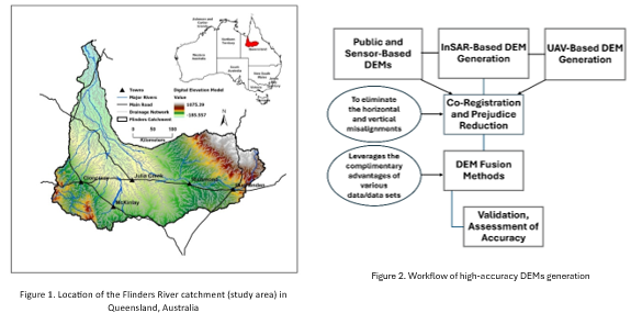
This PhD project develops an integrated remote sensing and modelling framework to assess flood-driven soil erosion and land degradation in Northern Queensland rangelands. Flood events in this region significantly reshape landscapes through gully erosion, sediment redistribution, and vegetation loss, posing risks to soil fertility, ecosystem resilience, and sustainable land management.
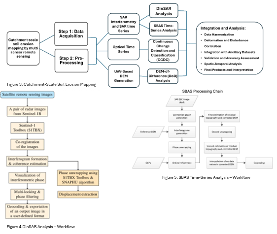
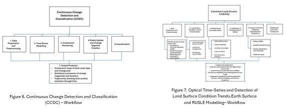
The research combines multi-sensor remote sensing data with advanced hydrodynamic modelling to monitor, quantify, and predict erosion processes. A key component involves generating high-resolution Digital Elevation Models (DEMs) by integrating multiple data sources, including Copernicus, TanDEM-X, ASTER, SRTM, ALOS, ICESat-2, UAV photogrammetry, and LiDAR. These datasets are used to produce a refined terrain baseline for hydrological and geomorphic analysis.
Time-series analysis using SAR (InSAR), optical satellite imagery (e.g., Sentinel-2 and Landsat), and UAV data enables the detection of landscape changes before and after flood events. These observations are coupled with catchment-scale erosion modelling approaches, including RUSLE and Trends.Earth indicators, to assess long-term land degradation patterns and identify erosion hotspots.
Additionally, 2D hydrodynamic models (e.g., HEC-RAS 2D or TUFLOW) simulate flood extent, depth, velocity, and shear stress. These outputs are integrated with sediment transport and erosion proxies to improve the understanding of erosion mechanisms and validate model performance against observed changes.
The project delivers a multi-scale, data-driven framework to support improved flood-impact assessment, inform land-management strategies, and enhance the resilience of rangeland ecosystems under increasing climate variability.
Project Team and Collaborators:
Laleh Jafari (PhD Candidate), supervised by Dr Ben Jarihani, Dr Jack Koci, Dr Stephanie Duce, Dr Ioan Stanislav, and Dr Dipak Paudyal at James Cook University (JCU). The project may also involve collaboration with remote sensing specialists, hydrologists, and regional land management stakeholders in Northern Queensland.
Funding Sources to be Acknowledged:
Australia’s Economic Accelerator (AEA) Seed and Ignite Funding