CADSI Our impact areas Nature Hyperspectral Satellite Monitoring of Post-Cyclone Water Quality in the Great Barrier Reef
Hyperspectral Satellite Monitoring of Post-Cyclone Water Quality in the Great Barrier Reef
- MRCMHR
- Future Students
- JCU Global Experience
- International Students
- Student experience
- Open Day
- How to apply
- Pathways to university
- Living on Campus
- Courses
- Publications
- Mature students
- Scholarships
- Entry options
- JCU Families
- JCU Heroes Programs
- Aboriginal and Torres Strait Islander in Marine Science
- Elite Athletes
- Defence
- Capability.Co
- AI@JCU
- AALL
- Current Students
- Student Ambassador Program
- New students
- JCU Orientation
- LearnJCU
- Placements
- EDQS
- Unicare Centre and Unicampus Kids
- Graduation
- Off-Campus Students
- JCU Job Ready
- Safety and Wellbeing
- JCU Prizes
- Professional Experience Placement
- Employability Edge
- Art of Academic Writing
- Art of Academic Editing
- Careers and Employability
- Health, Wellbeing and Belonging
- Career Ready Plan
- Careers at JCU
- Partners and Community
- School Outreach and Widening Participation
- Alumni
- International partnerships
- About JCU
- Reputation and Experience
- Chancellery
- Governance
- Celebrating 50 Years
- Academy
- Indigenous Engagement
- Education Division
- Research Festival
- Graduate Research School
- Research Division
- Research and Innovation Services
- CASE
- College of Business, Law and Governance
- College of Healthcare Sciences
- College of Medicine and Dentistry
- College of Science and Engineering
- MPE
- Anthropological Laboratory for Tropical Audiovisual Research (ALTAR)
- Rural Remote and Tropical Health Systems
- Agriculture Technology and Adoption Centre (AgTAC)
- Advanced Analytical Centre
- AMHHEC
- Aquaculture Solutions
- AMHRA
- JCU Digital Wellbeing Group
- ARCSTA
- Lions Marine Research Trust
- Australian Tropical Herbarium
- Australian Quantum & Classical Transport Physics Group
- Boating and Diving
- Clinical Psychedelic Research Lab
- Centre for Tropical Biosecurity
- Centre for Tropical Bioinformatics and Molecular Biology
- CITBA
- CMT
- Centre for Disaster Solutions
- CSTFA
- Cyclone Testing Station
- The Centre for Disaster Studies
- Daintree Rainforest Observatory
- Fletcherview
- JCU Eduquarium
- JCU Turtle Health Research
- MARFU
- Orpheus
- TESS
- JCU Ideas Lab
-
CADSI
- About us
-
Our impact areas
-
Nature
- AutoWeed: AI Sport Spraying for Smarter Weed Control
- Automated Detection and Counting of Flying-Foxes from Thermal Imagery
- Smart Detection of Marine Invasive Species for Biosecurity
- 3D LiDAR Mapping of Coral Restoration Gardens and Mangrove Ecosystems in Bali and Lombok, Indonesia
- Hyperspectral Satellite Monitoring of Post-Cyclone Water Quality in the Great Barrier Reef
- Automated Estimation of Snail Shell Volume and Morphology
- Health
-
Economies
- Smart Sugarcane Health Monitoring Platform with Satellite Remote Sensing and Machine Learning
- AutoFish: AI Phenotyping for Tropical Aquaculture
- Detecting Variety Contamination in Sugarcane Plots
- Automating South Sea Pearl Phenotyping Through Masking and Deep Learning Algorithms
- Non-Destructive, High-throughput Phenotyping for Aquaculture: NIR Spectroscopy for the “Forensic” Chemical Analysis of Akoya Oyster and Red Algae
- Remote Sensing and Hydrodynamic Modelling for Flood-Driven Soil Erosion in Northern Queensland
-
Communities
- Digital Twin Student
- The Place of AI in Higher Education Teaching, Learning and Assessment
- Beyond the Text: Exploring student engagement and perceptions of AI generated podcasts and infographics in higher education
- Guardrails or Handbrakes? How Australian Universities Frame AI in Policy, and the Dominance of Misconduct Narratives
- Equitable GenAI Co-Pilot for Engineering Education
- VEtheRBlocks: Teaching the Internet with AR and Toy Bricks
- Corrugation Control in Unsealed Roads: Mechanisms and Sustainable Solutions
-
Nature
- Capabilities
- Our people
- News
- Contact us
- CNL
- TARL
- eResearch
- Indigenous Education and Research Centre
- Past Course and Subject Handbooks
- Estate
- Work Health and Safety
- Staff
- Discover Nature at JCU
- Cyber Security Hub
- Association of Australian University Secretaries
- Services Division
- Environmental Research Complex [ERC]
- Foundation for Australian Literary Studies
- Gender Equity at JCU
- Give to JCU
- Indigenous Legal Needs Project
- Inherent Requirements
- IsoTropics Lab
- IT Services
- JCU Webinars
- JCU Events
- JCU Motorsports
- JCU Sport
- Library
- Mabo Decision: 30 years on
- Marine Geophysics Laboratory
- Office of the Vice Chancellor and President
- Outstanding Alumni
- Policy
- PAHL
- Queensland Research Centre for Peripheral Vascular Disease
- Rapid Assessment Unit
- RDIM
- Researcher Development Portal
- Roderick Centre for Australian Literature and Creative Writing
- Contextual Science for Tropical Coastal Ecosystems
- State of the Tropics
- Strategic Procurement
- Student profiles
- SWIRLnet
- TREAD
- TropEco for Staff and Students
- TUDLab
- VAVS Home
- WHOCC for Vector-borne & NTDs
- Media
- Copyright and Terms of Use
- Australian Institute of Tropical Health & Medicine
- JCU Respect
- Pay review
- Research
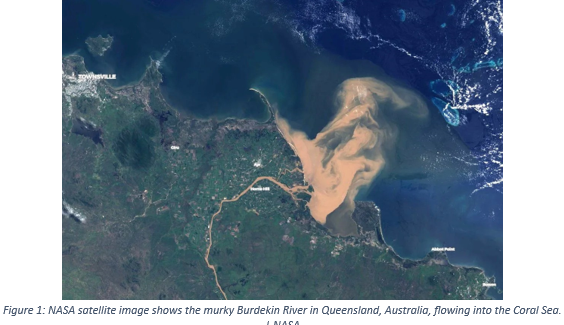
The Great Barrier Reef (GBR) is the world’s largest coral reef ecosystem and a UNESCO World Heritage Area, yet its inshore lagoon faces escalating water quality degradation from catchment-derived sediment and nutrients mobilised during cyclone events. Current GBR monitoring relies exclusively on multispectral satellites, MODIS, Sentinel-2, and Sentinel-3, which cannot separate co-varying optical signals from suspended sediment, coloured dissolved organic matter (CDOM), and phytoplankton, and systematically underestimate turbidity exposure duration on inshore reefs by a factor of 4–10 times.
This project pioneers the application of new-generation hyperspectral satellite sensors, PRISMA (239 bands, 400–2500 nm) and EnMAP (224 bands, 420–2450 nm), for post-cyclone water quality monitoring in the GBR, a combination never previously attempted.
The 2025–26 North Queensland cyclone season provides an extraordinary natural experiment: Tropical Cyclone Koji (Category 2) made landfall directly acoss the Burdekin River delta in January 2026, and Severe Tropical Cyclone Narelle (Category 4–5, comparable to Yasi 2011) crossed Cape York Peninsula in March 2026, two major events within 10 weeks, generating sediment plumes from both modified and pristine catchments.
AI enables optical water type classification, discriminating mineral sediment from organic floc and phytoplankton, that broadband multispectral sensors fundamentally cannot achieve.
Research outputs include validated open-source hyperspectral water quality algorithms for GBR waters, the first AI-trained spectral classification model for tropical reef flood plumes, and a practical monitoring protocol to support Reef 2050 Water Quality Improvement Plan policy implementation.
This project directly advances CADSI’s Nature impact domain through AI and remote sensing applied to one of Australia’s most critical ecosystems.
Project Team and Collaborators:
* Sofie Boggio Sella | MPhil Candidate, Earth and Environmental Science, JCU Townsville
* Dr Bren Jarihani | Principal Supervisor, Senior Lecturer in Earth and Environmental Science, CADSI, TNQ Drought Hub, JCU
* Dr Rafael Carvalho | Co-Supervisor, Lecturer in Physical Geography & Marine Remote Sensing, JCU
Funding Sources to be Acknowledged:
* JCU HDR Research Training Program Sponsorship
* 2026 TNQ Drought Hub Scholarship