-
Plants
- NQ Weeds by scientific name A-P
- NQ Weeds by scientific name P-Z
- NQ Weeds by common name
- Plants by scientific name A-F
- Plants by scientific name F-T
- Plants by scientific name T-Z
- Plants by common name A-L
- Plants by common name L-T
- Plants by common name T-Z
- Plants by Family (inc NQ Weeds)
-
Plants by life habit
- Plants by Flower Colour
- Plants on Cairns Campus
- Plants on Townsville Campus A-L
- Plants on Townsville Campus L-Z
- Douglas Campus Plant Species
- Plants of Magnetic Island (3rd Edition)
- Choosing Plants for Areas Prone to Cyclones
-
Fungi
-
Animals
-
Reptiles and amphibians by scientific name
- Hypsilurus boydii
- Litoria rubella
- Notoscincus ornatus
- Limnodynastes tasmaniensis
- Coeranoscincus frontalis
- Physignathus lesueurii
- Demansia vestigata
- Strophurus williamsi
- Cryptoblepharus pulcher
- Cyclorana alboguttata
- Tiliqua scincoides
- Furina ornata
- Dendrelaphis punctulata
- Hemidactylus frenatus
- Delma labialis
- Saproscincus basiliscus
- Lampropholis coggeri
- Boiga irregularis
- Ctenotus robustus
- Proablepharus tenuis
- Cryptoblepharus metallicus
- Eudynamys scolopacea
- Stegonotus cucullatus
- Litoria rothii
- Morethia taeniopleura
- Antaresia maculosa
- Liasis mackloti
- Ctenotus spaldingi
- Dendrelaphis calligaster
- Opisthodon ornatus
- Delma tincta
- Varanus varius
- Pseudonaja textilis
- Carlia rostralis
- Carlia decora
- Pseudechis porphyriacus
- Carlia storri
- Lygisaurus laevis (syn. Carlia laevis)
- Wollumbinia latisternum (syn. Elseya latisternum)
- Oedura castelnaui
- Litoria infrafrenata
- Litoria bicolor
- Amphibolurus nobbi nobbi
- Carlia schmeltzii
- Cryptoblepharus adamsi
- Morelia spilota
- Lampropholis delicata
- Lialis burtonis
- Cryptophis nigrostriatus
- Acrochordus granulatus
- Carlia longipes
- Carlia rubrigularis
- Cryptoblepharous virgatus
- Varanus tristis
- Furina diadema
- Varanus panoptes
- Chelodina canni
- Lygisaurus aeratus (syn. Carlia aerata)
- Litoria gracilenta
- Carlia munda
- Chlamydosaurus kingii
- Aspidites melanocephalus
- Glaphyromorphus punctulatus
- Lygisaurus foliorium (syn. Carlia foliorum)
- Varanus gouldii
- Litoria inermis
- Gehyra dubia
- Varanus scalaris
- Rhinella marina (syn. Bufo, syn. Chaunus)
- Diporiphora australis
- Cryptoblepharus metallicus
- Cyclorana novaehollandiae
- Oxyuranus scutellatus
- Cryptoblepharus plagiocephalus
- Heteronotia binoei
- Litoria caerulea
- Bellatorias frerei (syn. Egernia frerei)
- Diplodactylus conspicillatus
- Lepidodactylus lugubris
- Gehyra nana
- Vermicella annulata
- Demansia torquata
- Ctenotus taeniolatus
- Cryptoblepharus litoralis
- Furina barnardi
- Demansia papuensis
- Litoria fallax
- Ramphotyphlops affinis
- Glaphyromorphus nigricaudis
- Litoria nasuta
- Ramphotyphlops braminus
- Carlia jarnoldae
- Litoria lesueuri
- Tropidonophis mairii
- Morelia amethistina
- Enhydris polylepis
- Oedura rhombifer
- Menetia greyii
- Cyclodomorphus gerrardii
-
Miscellaneous fauna
- Ephippitytha spp.
- Nephila spp.
- Macrobrachium spp.
- Monomorium pharaonis
- Diplacodes trivialis
- Lampromicra ?senator
- Crocothemis nigrifrons
- Caenoplana coerulea
- Iridomyrmex sp.
- Aphaenogaster barbara
- Trigona sp.
- Amitermes laurensis
- Odontomachus sp.
- Rhytidoponera metallica
- Crematogaster sp
- Pheidole megacephala
- Caenoplana sp.
- Camponotus novaehollandiae
- Sparassidae
- Ropalidia revolutionalis
- Monomorium floricola
- Bipalium kewense
- Goniaea sp.
- Lophyrotoma leachii
- Tetraponera punctulata
- Dolichoplana sp.
- Oecophylla smaragdina
- Opisthopsis haddoni
- Paratrechina longicornis
- Polyrhachis sp.
- Iridomyrmex reburrus
- Holconia immanis
- Rhyothemis graphiptera
- Platydemus manokwari
- Meranoplus sp
- Xylotrupes gideon
- Monomorium rothsteini
- Orthetrum caledonicum
- Argiope keyserlingi
- Thomisus spectabilis
- Batocera boisduvali
-
Fish by scientific name
- Oreochromis mossambicus
- Leiopotherapon unicolor
- Kuhlia rupestris
- Nematolosa erebi
- Hypseleotris compressa
- Ambassis agassizii
- Haplochromis burtoni
- Anguilla reinhardtii
- Craterocephalus stercusmuscarum
- Amniataba percoides
- Neosilurus hyrtlii
- Poecilia reticulata
- Melanotaenia splendida splendida
- Mogurnda adspersa
- Neosilurus ater
- Xiphophorus maculatus
-
Birds by scientific name
- Gymnorhina tibicen
- Haliaeetus leucogaster
- Grallina cyanoleuca
- Turnix pyrrhothorax
- Hirundo neoxena
- Philemon corniculatus
- Cuculus saturatus
- Pachycephala rufiventris
- Coracina papuensis
- Centropus phasianinus
- Zosterops lateralis
- Philemon citreogularis
- Alectura lathami
- Dacelo novaeguineae
- Corvus orru
- Vanellus miles
- Trichoglossus haematodes
- Podargus strigoides
- Neochmia modesta
- Passer domesticus
- Oriolus flavocinctus
- Merops ornatus
- Dacelo leachii
- Platycercus adscitus
- Rhipidura leucophrys
- Podargus papuensis
- Haliastur indus
- Meliphaga gracilis
- Philemon buceroides
- Myzomela obscura
- Ninox connivens
- Corvus coronoides
- Lichmera indistincta
- Trichoglossus chlorolepidotus
- Coracina tenuirostris
- Dichaeum hirundinaceum
- Pitta versicolour
- Alcedo azurea
- Dicrurus bracteatus
- Taeniopygia guttata
- Falco longipennis
- Myiagra rubecula
- Geopelia striata
- Oriolus sagittatus
- Chrysococcyx minutillus
- Cacatua galerita
- Taeniopygia bichenovii
- Falco berigora
- Struthidea cinerea
- Chlamydera nuchalis
- Chrysococcyx basalis
- Ocyphaps lophotes
- Falco cenchroides
- Eudynamys scolopacea
- Todiramphus sanctus
- Coracina novaehollandiae
- Cacomantis variolosus
- Accipter novaehollandiae
- Entomyzon cyanotis
- Haliastur sphenurus
- Rhipidura fuliginosa
- Ptilinopus magnificus
- Lichenostomus unicolor
- Geopelia humeralis
- Aplonis metallica
- Cisticola exilis
- Todiramphus macleayii
- Aegotheles cristatus
- Nectarina jugularis
- Tanysiptera sylvia
- Ninox novaeseelandiae
- Acridotheres tristis
- Lalage leucomela
- Myzomela sanguinolenta
- Cacomantis flabelliformis
- Cacatua roseicapilla
- Neochmia phaeton
- Threskiornis molucca
- Streptopelia chinensis
- Ducula bicolor
- Collocalia spodiopygius
- Ramsayornis modestus
- Poecilodryas superciliosa
- Lonchura punctulata
- Burhinus grallarius
- Sphecotheres viridis
- Accipiter cirrhocephalus
- Coturnix ypsilophora
- Tyto alba
- Anseranus semipalmata
- Lonchura castaneothorax
- Threskiornis spinicollis
- Falco peregrinus
- Rhipidura rufifrons
- Artamus leucocorynchus
- Scythrops novaehollandiae
- Malurus melanocephalus
- Chrysococcyx osculans
- Alcedo pusilla
- Aviceda subcristata
- Melithreptus albogularis
- Megapodius reinwardt
- Cracticus nigrogularis
- Cracticus quoyi
- Aprosmictus erythropterus
- Aquila audax
- Milvus migrans
- Gerygone palpebrosa
- Lophoictinia isura
- Calyptorhynchus banksii
- Cacatua sanguinea
- Lichenostomus flavus
- Antus novaeseelandiae
- Meliphaga notata
- Glossopsitta pusilla
- Colluricincla megarhyncha
- Eurystomus orientalis
-
Butterflies and Moths by scientific name
- Jalmenus daemeli
- Philiris innotatus
- Hypochrysops apelles
- Catopsilia gorgophone
- Opodiphthera eucalypti
- Graphium macleayanus
- Eurema herla
- Hypolimnas bolina
- Mycalesis terminus
- Psychonotis caelius
- Candalides erinus
- Catopyrops florinda
- Argina astrea
- Discover NATURE
- Psychidae A
- Cupha prosope
- Arhopala centaurus
- Zizina labradus
- Polyura sempronius
- Catopsilia pyranthe
- Mycalesis sirius
- Eurema alitha
- Danaus plexippus
- Sahulana scintillate
- Sabera dobbae
- Junonia orithya
- Tirumala hamata
- Delias nigrina
- Danaus chrysippus
- Junonia hedonia
- Graphium agamemnon
- Acraea andromacha
- Arhopala madytus
- Theclinesthes onycha
- Papilio aegeus
- Appias paulina
- Nacaduba berenice
- Oxybadistes hypomeloma
- Eurema smilax
- Ogyris oroetes
- Pantoporia consimilis
- Graphium sarpedon
- Discover NATURE
- Melanitis leda
- Graphium euryplus
- Ochrogaster lunifer
- Belenois java
- Cephrenes augiades
- Nacabuba biocellata
- Euploea core
- Hypocysta adiante
- Delias mysis
- Phaedyma shepherdi
- Prosotas dubiosa
- Euploea tulliolus
- Delias argenthona
- Hypolycaena phorbas
- Elodina queenslandica
- Eurema brigitta
- Zizula hylux
- Mycalesis perseus
- Theclinesthes miskini
- Jamidis phaseli
- Papilio anactus
- Hypolycaena danis
- Ythima arctous
- Eurema hecabe
- Pieris rapae
- Vanessa kershawi
- Hypochrysops digglesii
- Elodina padusa
- Tagiades japetus
- Cressida cressida
- Discover NATURE
- Chaetocneme denitza
- Discover NATURE
- Doleschallia bisaltide
- Discover NATURE
- Pelopidas lyelli
- Lampides boeticus
- Catochrysops panormis
- Cepora perimale
- Catopsila pomona
- Anthene seltuttus
- Catopsilia scylla
- Deudorix diovis
- Famegana alsulus
- Ogyris zosine
- Cethosia cydippe
- Rapala varuna
- Discover NATURE
- Freyeria putli
- Pelopidas agna
- Hypolimnas alimena
- Ornithoptera euphorion
- Euchrysops cnejus
- Cephrenes trichopepla
- Nacaduba cyanea
- Papilio fuscus
- Vindula arsinoe
- Zizeeria karsandra
- Tellervo zoilus
- Neptis praslini
- Discover NATURE
- Arhopala micale
- Hasora chromus
- Papilio ulysses
- Hypochrysops ignita
- Coscinocera Hercules
- Toxidia thyrrhus
- Liphyra brassolis
- Anthene lycaenoides
- Eurema laeta
- Cephonodes kingii
-
Mammals by scientific name
- Pogonomys mollipilosus
- Canis lupus dingo
- Miniopterus australis
- Macropus giganteus
- Myotis moluccarum
- Chaerephon jobensis
- Macropus agilis
- Syconycteris australis
- Pteropus conspicillatus
- Scotorepens sanborni
- Saccolaimus flaviventris
- Rattus rattus
- Chalinobolus gouldii
- Isoodon macrourus
- Pteropus alecto
- Trichosurus vulpecula
- Tachyglossus aculeatus
- Melomys cervinipes
- Tadarida australis
- Pteropus scapulatus
- Hydromys chrysogaster
- Rhinolophus megaphyllus
- Dactylopsila trivirgata
- Sus scrofa
- Planigale maculata
- Melomys burtoni
- Mus musculus
- Pseudomys gracilicaudatus
- Antechinus flavipes
- Reptiles and Amphibians by common name
- Birds by common name
- Fish by common name
- Mammals by common name
- Butterflies and Moths by common name
-
Reptiles and amphibians by scientific name
- Field Study Sites
- Contributors
- Contact us
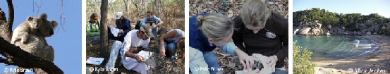
Discover Nature at JCU Field Study Sites Magnetic Island
Magnetic Island
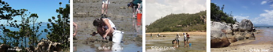
Magnetic Island is a continental island offshore from Townsville. A large continental island of 5184 ha, it rises to 493 m at Mt Cook, the highest point. Much of the island is rugged and composed of granodiorite except for the West Point area where there are mainly acid agglomerates. There is a diversity of habitats from the mangrove communities on the shoreline to the dunes and salt flats through woodland to vine thickets and some rainforest patches in protected gullies. The fringing reefs are easily accessible at low tide. Because of its diversity and close proximity to Townsville (8 km, 25 minutes by ferry), it is regularly used for field studies by students and staff from many disciplines. There is estuarine and marine geomorphological diversity as well as high diversity of flora and fauna. Earth science students use the island to study island, reef and beach evolution as part of a 3 week field work course. The fringing reefs support many coral communities with extensive seagrass communities associated with the reef flats. There is an extensive use history of aboriginal use, many artefacts have been identified.